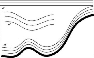
The Hybrid Coordinate Ocean Model (HYCOM) is a primitive equation model, that combines the optimal features of isopycnic-coordinate and fixed-grid ocean circulation models within one framework (Bleck, 2002). At each time-step of the model integration, HYCOM determines an optimal hybrid layer distribution, interchanging between isopycnic (ρ) vertical coordinates when simulating the stratified open ocean, z-level coordinates when resolving upper-ocean mixed layer dynamic processes and terrain-following σ-coordinates in the shallow coastal regions (see the left figure below).
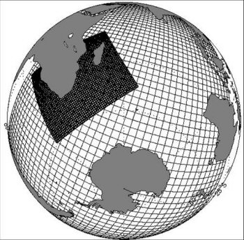
The figure (left) provides an illustration of the three different vertical coordinate schemes utilised in HYCOM. The figure (right) is an illustration of the HYCOM model system used to simulate the Agulhas Current region.
During these vertical coordinate interchanges, emphasis is placed on restoring the grid to isopycnic coordinates. The adaptive (hybrid) vertical grid conveniently resolves regions of vertical density gradients, such as the thermocline and surface fronts.
In a collaborative effort between the Department of Oceanography, at the University of Cape Town and the Mohn-Sverdrup Centre for Global Ocean Studies and Operational Oceanography at the Nansen Environmental and Remote Sensing Centre in Bergen, Norway, a 1/10° HYCOM was set up to simulate the Agulhas system (see the right figure above). The main objective of this work was to develop HYCOM for mesoscale modelling of the region, which included performing a hindcast simulation experiments and validating the model fields against satellite remote sensing and in-situ data as well as implementing and testing new model developments. The results of which have been published in peer-reviewed journals: Backeberg et al., 2008; Backeberg et al., 2009, Backeberg and Reason, 2010.
Above is an animation of the surface currents simulated in HYCOM for the greater Agulhas Current region.
HYCOM is presently used operationally at the Naval Research Laboratory in collaboration with the HYCOM Consortium for data-assimilative ocean modelling. A global model provides daily 5 day hindcast and forecasts of currents, temperatures and salinities at standard Levitus depths. In another example of operational applications of HYCOM, the Mohn-Sverdrup Centre / Nansen Centre (Norway) runs a basin-scale high resolution model of the Atlantic Ocean which provides surface current forecasts used at the ECMWF for wave forecasting.
Current activities include the further development of HYCOM for mesoscale modelling of the Agulhas region, for potential implementation as one component of the operational system.
References:
Backeberg, B. C., L. Bertino, and J. A. Johannessen (2009). Evaluating two numerical advection schemes in HYCOM for eddy-resolving modelling of the Agulhas Current. Ocean Sci., 5, 173-190.
Backeberg, B. C., J. A. Johannessen, L. Bertino, C. J. Reason (2008). The greater Agulhas Current system: An integrated study of its mesoscale variability. Journal of Operational Oceanography, 1(1):29-44(16).
Backeberg, B. C. and C. J. C. Reason (2010). A connection between the South Equatorial Current north of Madagascar and Mozambique Channel Eddies. Geophys. Res. Lett., 37, L04604, doi:10.1029/2009GL041950.
Bleck, R. (2002). An oceanic general circulation model framed in hybrid isopycnic-Cartesian coordinates. Ocean Modell. 37, 55–88.