


Natal Bight
Dowload the PDF of this lesson by clicking here
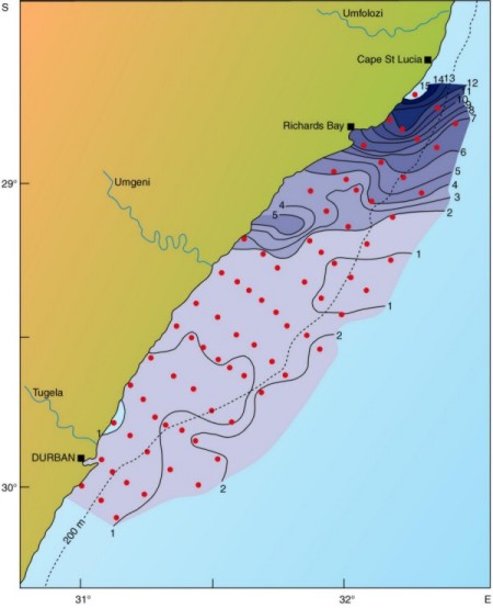 |
South Africa's east coast has a uniformly narrow shelf, except for the Natal Bight, which is an unusually wide coastal offset. It lies between Cape St Lucia and Durban, is about 160km long, and off the mouth of the Tugela River it is broadest about 50 km wide). The shelf break occurs at approximately the 200 m isobath with a relatively steep slope towards the sea. The Agulhas Current follows this shelf break closely, enclosing the body of water in the Bight, and strongly influencing the shelf circulation. The water in the Bight is well-mixed, and is made up of Indian Tropical Surface Water and South Indian Subtropical Surface Water. (Lutjeharms et al., 2000) An upwelling cell north of Richards Bay has been identified, and is referred to as the Cape St Lucia upwelling cell. High concentrations of nutrients occur in this cell as colder, saltier and nutrient rich water is brought onto the shelf from the South Indian Subtropical Surface Water. Lutjeharms et al. (2000) reported on a cross-shelf front bisecting the central part of the Bight. Between the cell and this front there is a steady decrease in nutrients (refer to Figure 1). The nutrients from this cell substantially influence the phytoplankton productivity of the Bight. The upwelling cell is present at the upstream end of a broadening shelf, and is topographically driven by the swift flowing Agulhas Current. (Lutjeharms et al., 2000) |
|
Figure 1 |
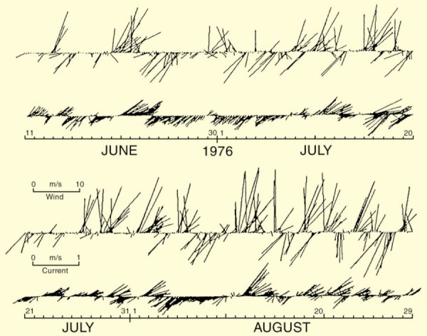 |
Gründlingh (1974) reported on inshore current reversals occurring off Richards Bay, which have been shown to correlate well with synoptic winds (refer to Figure 2). The Natal Bight has been shown to be the inception region for the Natal pulse (Lutjeharms et al., 2000). Understanding this region is thus important due to the effect these pulses exert on the Agulhas Current, as well as the production resulting from the Cape St Lucia upwelling cell. |
|
Figure 2 |
CLASSIC PAPER
Lutjeharms, J. R. E., Valentine, H. R. and Van Ballegooyen, R.C. (2000). The hydrography and water masses of the Natal Bight, South Africa. Continental Shelf Research, 20,1907-1939.
Bibliography
- Gründlingh, M. L. (1974). A description of inshore current reversals off Richards Bay based on airborne radiation thermometry. Deep Sea Research and Oceanographic Abstracts, 21 (1), 47-55.
- Malan, O. G. and Schumann, E. H. (1979). Natal shelf circulation features revealed by LANDSAT imagery. South African Journal of Science, 75, 136-137.
- Martin, A. K. and Flemming, A. K. (1988). Physiography, structure and geological evolution of the Natal continental shelf. In: E.H. Schumann, (Ed.), Lecture Notes on Coastal and Estuarine Studies. Springer-Verlag, New York, pp. 11-46.
- Meyer, A. A., Lutjeharms, J.R.E. and de Villiers S. (2002). The nutrient characteristics of the Natal Bight, South Africa. Journal of Marine Systems, 35, 11- 37.
- Schumann, E. H. (1988). Physical oceanography off Natal. In: E.H. Schumann, (Ed.), Lecture Notes on Coastal and Estuarine Studies. Springer-Verlag, New York, pp. 101-130.
